


Terrain Radar
Terrain Radar의 설명
Discover the Power of Terrain with Terrain Radar!
Unlock the potential of precise elevation measurements with Terrain Radar, the go-to app for professionals and outdoor enthusiasts alike. Whether you’re a hiker, biker, surveyor, or civil engineer, this app delivers essential topography insights at your fingertips.
Why Terrain Radar?
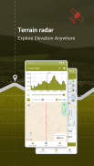
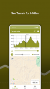
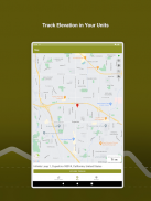
Imagine having a powerful radar for the terrain around you. With Terrain Radar, you can explore detailed elevation data and visualize it on a sleek graph and interactive map. Measure distances ranging from as short as 300 feet to as far as 6 miles. Want to change direction? Simply use your phone's sensors or set the direction manually within the app's intuitive interface.
Key Features:
📊 Accurate Elevation Mapping: Get real-time elevation data displayed on a customizable map. Perfect for understanding terrain profiles for hiking, urban planning, and more.
📏 Adjustable Distance: Control the distance you want to measure—from 300 feet to a maximum of 6 miles, offering flexibility for any task.
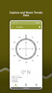
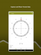
🧭 Built-in Compass: Always know your bearings with the integrated compass, designed to help you navigate and adjust directions for accurate measurements.
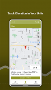
🗺️ Versatile Mapping Options: Choose from a variety of map formats to suit your preference, and measure not only in your current location but anywhere on the map.
📸 Share Your Findings: Easily share your measurement data in the form of photos. Share stunning snapshots of terrain measurements with colleagues, friends, or clients.
⚙️ Customizable Settings: Select between metric and imperial units depending on your needs, and experience seamless integration for various professional fields, from geology to forestry management.
🎓 Comprehensive Tutorial: New to Terrain Radar? No problem! The built-in tutorial guides you step-by-step, making sure you can use all of the app’s powerful features with ease.
Designed for Professionals & Adventurers From geologists and urban planners to environmental scientists and outdoor guides, Terrain Radar offers powerful tools for those who rely on detailed terrain and topography insights. Whether you’re exploring new paths or assessing land for development, our app is your trusted companion.
Experience the best in terrain mapping, gain deeper insights, and stay ahead of the curve with Terrain Radar.
Download now and transform the way you see the world beneath your feet!
Privacy Policy: https://mysticmobileapps.com/legal/privacy/terrainradar
Terms and conditions: https://mysticmobileapps.com/legal/terms/terrainradar
Terrain Radar - 버전 1.13
(27-03-2025)Terrain Radar - APK 정보
APK 버전: 1.13패키지: com.mysticmobileapps.terrain.radar


 3.79
3.79

동일 카테고리의 앱


